Staying Safe on Mount Hood
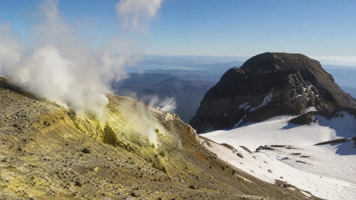
The upper mountain
The USFS climbing page lists the hazards of the summit climb: avalanches, climber congestion, glacial features and fumarole holes, icefall and rockfall, long sliding falls, and weather. Each has a place on the South Side route:
- Fumaroles. In the Devil’s Kitchen and Hot Rocks areas of the south side crater, volcanic vents create "deep holes and cracks in the snow", per the USFS.
- Crevasses and the bergschrund. The route crosses glacier terrain, with a bergschrund below the summit chutes. The crevasses page explains them.
- Rockfall and icefall. The USFS advises starting very early to be "up and back down from overhead hazard zones like the Old Chute area before they’re in the sun". In late summer 2026 it stated that "Rockfall will be your primary hazard on the upper mountain this time of year" and that rangers no longer recommend a summit attempt for the rest of the season.
- Long sliding falls. Steep snow in the chutes means a slip can turn into a long fall.
- Weather. Conditions on an exposed summit can change during a climb.
The climbing page covers the route in order.
Turnaround times
A common approach is to set a fixed time at which the party turns back, summit or not, so that the descent happens before snow softens and rockfall increases. This is a general mountaineering practice, not a USFS rule. The two pm rule page explains the idea and its limits.
Locator devices
Mountain Locator Units, the radio beacons once rented for Mount Hood climbs, were used from the late 1980s until 2017 and then discontinued, because personal locator beacons and satellite messengers give better location data. Some older route pages still mention renting them. A PLB or a satellite messenger is the current equivalent. The what to pack page lists the rest of the kit.
Condition reports and registration
The USFS publishes climbing condition reports on Tuesday and Friday mornings through early summer, and climbers register in the Wy’East Day Lodge at Timberline. A Mt. Hood Climbing Permit is required above 9,500 ft; the climbing permit page covers it. Whether to climb with a guide is covered on do you need a guide.
On the trails
- River fords. The Timberline Trail fords the Newton, Coe, Muddy Fork, Sandy and White Rivers, "typically not more than knee deep" per the USFS, plus the Eliot Branch. At Ramona Falls the Sandy River has no bridge; the USFS states "There is no bridge, nor will one be installed."
- Snow. High trails are in season July to October, and McNeil Point often holds snow through June, per the USFS. The best time to hike page has meltout dates.
- Blowdown. The USFS reports significant blowdown between Muddy Fork and Yocum Ridge on the Timberline Trail, and notes the trail is not fully maintained.
- Fire. Wildfires closed a number of trails on the east side of the mountain in late summer 2026; check the Mt. Hood National Forest alerts page before setting out.
Wildlife
The USFS "Respect Wildlife" page names black bears, cougars, deer and Chinook salmon in the forest. Its advice is to "Never approach or feed wild animals" and to store food, including pet food. The USFS notes that cougars "inhabit most of the forest region" and asks visitors to report aggressive behavior to the Oregon Department of Fish and Wildlife.
The volcano
Mount Hood is a stratovolcano, and the USGS rates its threat level "Very High". The most recent eruption the USGS lists is 1865, and the last major eruptive period, the Old Maid, was about 1781. The USGS names lahars, mudflows formed when hot flows melt snow and ice or when slopes collapse, as the primary hazard, and monitors the mountain with 5 seismic stations within 12 miles. The USGS Mount Hood page and the volcano page have more.
Winter roads
US-26 reaches about 4,000 ft at Government Camp. Oregon’s chain law applies in winter, with signs showing the current requirement, per ODOT; TripCheck.com and 511 give road conditions.
The 1986 accident
In May 1986, nine members of an Oregon Episcopal School climbing party, seven students and two faculty members, died after a storm on the mountain, according to the school. Eleven members of the party survived.
The USFS climbing conditions report, the Mt. Hood National Forest alerts page and TripCheck together cover the upper mountain, the trails and the road on the day of a trip.
For a day at the mountain without driving
For visitors who want to see the mountain without the climb or the winter drive, the Portland: Mt. Hood Day Tour lists hotel pickup in central Portland and 30 minutes at Timberline Lodge. Its listing states that it runs in all weather unless unsafe.
Frequently asked questions
Is Mount Hood dangerous to climb?
The USFS lists avalanches, climber congestion, glacial features and fumarole holes, icefall and rockfall, long sliding falls, and weather as hazards. See the climbing page.
What should climbers carry to call for help?
A personal locator beacon or a satellite messenger. Mountain Locator Units were discontinued in 2017. The what to pack page lists more.
Are there bears on Mount Hood?
The USFS names black bears and cougars among the forest’s wildlife and asks visitors never to approach or feed wild animals. See the day hikes page for trails.
Is Mount Hood an active volcano?
Yes. The USGS rates its threat level "Very High" and lists 1865 as the most recent eruption. See is Mount Hood a volcano.